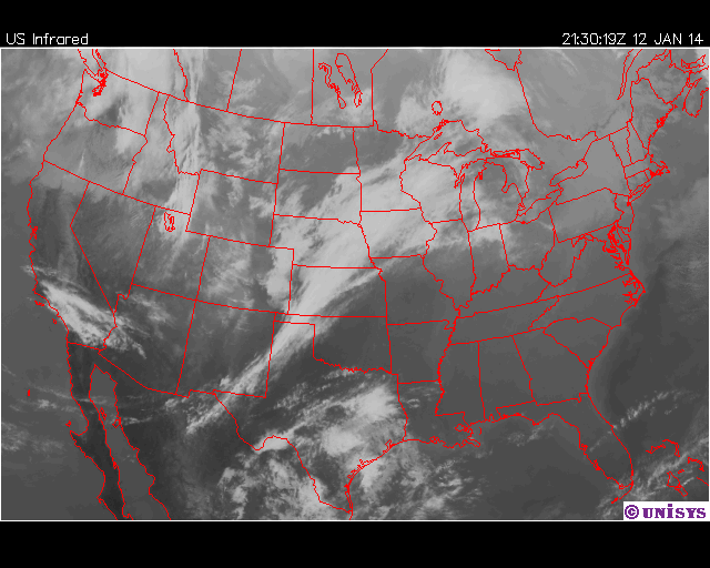
Good afternoon everyone and thanks for stopping by the Cheatham County Weather Blog. In case you didn't know, we have created an 'experimental' Instagram account which will be used to receive Severe and Winter Weather reports from followers. Just click the Instagram Badge on the left hand column. Our low this morning was 29° and the current temperature as of 3:51 P.M. CDT is 56°. The big story for our weather today is high pressure. This is the reason for the mostly sunny skies and the warm temperatures. The high pressure is centered over the panhandle of Florida. Winds around high pressure flow clockwise, and because of this our winds have been from the south today at 5 mph. A surface low pressure system is located over Kansas and Oklahoma and an area of moisture is located over eastern Texas. These two features will be the reason we receive rain tomorrow.
 |
| Figure 1: Infrared Satellite valid for Sunday, January 12 at 3:30 P.M. CDT. |
Forecast Discussion:
For the rest of today, winds will remain out of the south at 5 mph. The low pressure located over Kansas and Oklahoma will continue to push east tonight into tomorrow, and the moisture over eastern Texas will merge with the system. As it stands right now, rain will move into the county by 7:00 A.M. CDT tomorrow ahead of a cold front. 0.10" - 0.25" of rain will be possible. Rain will be light to moderate at times and last until 6:00 P.M. CDT with the cold front moving through early Tuesday Morning. Lows Tuesday morning will be in the mid 30s. Monday night into Tuesday, our next ow pressure system (commonly named a clipper system) will begin to make it's way down from Saskatchewan, Canada and will move just to our north. Current models are indicating a little bit of precipitation late Tuesday Night into early Wednesday morning and due to the cold temperatures that will be in place, any precipitation that falls will be snow. However, no snow accumulation is expected. Wednesday, once the early morning precipitation moves out, high pressure will be in control causing our temperatures to remain cold on Wednesday.
 |
| Figure 2: Quantitative Precipitation Forecast for Monday, January 13. |
Tonight: Expect a low of 46° with winds south at 5 mph. Clear skies becoming partly to mostly cloudy after midnight. No precipitation expected.
Monday: Start off with a low of 43° and expect a high temperature of 53°. Winds out of the south at 10-15 mph. Rain will move in around 9:00 A.M. CDT. Light to moderate rain is possible. Chance of rain is 95%.
Monday Night: Expect a low of 42° before midnight. Rain will be moving out by 6:00 P.M. CDT. Rain totals will be from 0.10" - 0.25". Chance of rain is 80% Winds will be out of the west at 8-10 mph.
Tuesday: Low of 33° to start out and high will be 50° under partly cloudy skies. Winds will be out of the southwest at 10-15 mph. No precipitation expected.
Tuesday Night: Low of 31° before midnight with winds out of the southwest at 5-10 mph becoming northwest at 10-15 mph. Light snow is possible after midnight with no accumulation expected. Chance of precipitation is 40%.
Wednesday Low of 28° and expect a high of 35°. Snow will still be around in the early morning hours and should move out by noon. No accumulation expected. Chance of precipitation is 30%.
Wednesday Night: Expect a low of 29° before midnight with winds out of the northeast at 5 mph becoming south at 5 mph. No chance of precipitation.
Have a great week!
Tyler Binkley
No comments:
Post a Comment