Alerts

None

Headlines:

A few flurries will continue today into tonight with no accumulation expected. Our next chance of snow will come Thursday as another clipper system comes in from the Northwest.

<------- If you haven't already, be sure to follow us on Instagram at cheatham_county_weather.

Wednesday, January 15, 2014

Weekend outlook

Current Conditions:

Good afternoon.  Snow flurries continue for today (Wednesday, Jan 15) and will continue into tonight.  Currently a trough axis stretches from Ontario, Canada down to Mississippi.  Cold air advection is occurring which has allowed our temperatures to be cold today.  Moisture is not present since the dewpoint is 15°, however there is enough moisture to allow a few snow flurries to fall.  At the surface, a surface high is located over southern Texas and a surface low is located over Manitoba Canada.  Current temperature is 31° under mostly cloudy skies.  A few snow flurries are still flying.  Our low this morning was 25°.  Now let's take a look at the rest of the week into the weekend.

Visible Satellite valid for 2:30 P.M. CDT on Wed. Jan. 15.
 Forecast Discussion:

The trough axis mentioned early will continue to move off to the east allowing our next clipper system to move in tomorrow.  The system tomorrow will come from the northwest as a surface low passes just to our north.  As the low approaches, winds will turn out of the south at 10-15 mph which will help our temperatures to warm up.  Precipitation associated with this system will move in tomorrow afternoon/evening and will be very light.  Due to the temperature warming up tomorrow, precipitation will start as rain and change over to snow as colder temperatures push in.  Again precipitation will be very light with no snow accumulation expected.  Friday, will be colder with light snow showers/flurries possible in the morning becoming clear.  Saturday, high pressure will be in control before another clipper system moves through Saturday afternoon and evening that could bring us some more light precipitation.  Sunday, expect the clipper system to move out of the area.

Days at a glance:

Tonight:  Expect a low of 26° before midnight with winds out of the northwest at 5 mph.  Can't rule out some lingering snow flurries.  Chance of precipitation is 20%

Thursday:  Expect a morning low of 23° and a high of 45° partly cloudy skies.  Winds out to the northwest at 5 mph becoming south 10-15 mph.  Light precipitation will move in early afternoon - early evening.  Chance of precipitation is 20%

Thursday Night:  Low of 31° before midnight with winds out to the southwest at 5 mph.  Light rain changing to snow as the temperature drops.  No snow accumulation expected.  Chance of precipitation is 30%.  

Friday:  Expect a low of 27° and a high of 29° under mostly cloudy skies with winds west at 5-10 mph.  Lingering snow showers will continue through the morning into the early afternoon.  Little to no accumulation expected.  Chance of precipitation is 20%.

Friday Night: Expect a low of 20° before midnight with winds west at 5 mph.  No precipitation expected.  

Saturday:  Morning low of 16° and a high of 41° under partly cloudy skies.  Winds will be southwest at 5-10 mph.  No precipitation expected. 

Saturday Night:  Low temperature of 28° before midnight with winds west at 10 mph.  A system will move through bringing some light precipitation.  Chance of precipitation is 20%

Sunday:  Expect a low of 25° and a high temperature of 42° under mostly cloudy skies.  Winds will be west at 5 mph becoming southwest at 5-10 mph.  Light precipitation before noon as the system moves out.  Chance of precipitation is 20%. 

Sunday Night:  Low of 30° before midnight.  Winds out of the southwest at 5 mph.  No precipitation expected. 

Have a great rest of the week!  Be sure to follow us on Twitter and like us on Facebook for the latest weather information for Cheatham County, TN.

Tyler Binkley
       

Sunday, January 12, 2014

Wet weather headed our way in the form of rain and snow?

Current Conditions:

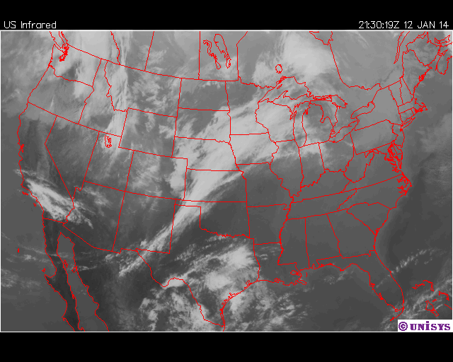
Good afternoon everyone and thanks for stopping by the Cheatham County Weather Blog.  In case you didn't know, we have created an 'experimental' Instagram account which will be used to receive Severe and Winter Weather reports from followers.  Just click the Instagram Badge on the left hand column.  Our low this morning was 29° and the current temperature as of 3:51 P.M. CDT is 56°.  The big story for our weather today is high pressure.  This is the reason for the mostly sunny skies and the warm temperatures.  The high pressure is centered over the panhandle of Florida.  Winds around high pressure flow clockwise, and because of this our winds have been from the south today at 5 mph.  A surface low pressure system is located over Kansas and Oklahoma and an area of moisture is located over eastern Texas.  These two features will be the reason we receive rain tomorrow.  

Figure 1:  Infrared Satellite valid for Sunday, January 12 at 3:30 P.M. CDT.
Forecast Discussion:

For the rest of today, winds will remain out of the south at 5 mph.  The low pressure located over Kansas and Oklahoma will continue to push east tonight into tomorrow, and the moisture over eastern Texas will merge with the system.  As it stands right now, rain will move into the county by 7:00 A.M. CDT tomorrow ahead of a cold front.  0.10" - 0.25" of rain will be possible.  Rain will be light to moderate at times and last until 6:00 P.M. CDT with the cold front moving through early Tuesday Morning.  Lows Tuesday morning will be in the mid 30s.  Monday night into Tuesday, our next ow pressure system (commonly named a clipper system) will begin to make it's way down from Saskatchewan, Canada and will move just to our north.  Current models are indicating a little bit of precipitation late Tuesday Night into early Wednesday morning and due to the cold temperatures that will be in place, any precipitation that falls will be snow.  However, no snow accumulation is expected.  Wednesday, once the early morning precipitation moves out, high pressure will be in control causing our temperatures to remain cold on Wednesday.


Figure 2:  Quantitative Precipitation Forecast for Monday, January 13.

Tonight:  Expect a low of 46° with winds south at 5 mph.  Clear skies becoming partly to mostly cloudy after midnight.  No precipitation expected.  

Monday:  Start off with a low of 43° and expect a high temperature of 53°.  Winds out of the south at 10-15 mph.  Rain will move in around 9:00 A.M. CDT.  Light to moderate rain is possible.  Chance of rain is 95%. 

Monday Night:  Expect a low of 42° before midnight.  Rain will be moving out by 6:00 P.M. CDT.  Rain totals will be from 0.10" - 0.25".  Chance of rain is 80%  Winds will be out of the west at 8-10 mph.

Tuesday:  Low of 33° to start out and high will be 50° under partly cloudy skies.  Winds will be out of the southwest at 10-15 mph.  No precipitation expected. 

Tuesday Night:  Low of 31° before midnight with winds out of the southwest at 5-10 mph becoming northwest at 10-15 mph.  Light snow is possible after midnight with no accumulation expected.  Chance of precipitation is 40%.  

Wednesday  Low of 28° and expect a high of 35°.  Snow will still be around in the early morning hours and should move out by noon.  No accumulation expected.  Chance of precipitation is 30%. 

Wednesday Night:  Expect a low of 29° before midnight with winds out of the northeast at 5 mph becoming south at 5 mph.  No chance of precipitation.  

Have a great week!  

Tyler Binkley                  

Wednesday, January 8, 2014

Big warm up in store after below zero temperatures!


Current Conditions:

Like Bill Cosby, I'm sure a lot of people are going to be saying Hallelujah when they see the temperatures for this weekend.  A fairly zonal flow exists over our area in the upper part of the atmosphere indicating calm conditions.  Upper level moisture is not present over our area, however winds are out of the southwest bringing clouds from a low pressure system located over Texas.  Since the winds are out of the south, Warm Air Advection is occurring allowing our temperatures to warm up considerably compared to what it has been the past few days.  At the surface, high pressure is centered over Virginia and North Carolina. Since winds around high pressure flow clockwise, this is the reason for the winds being out of the south/southwest today.  Current temperature as of 2:52 P.M. CDT is 39° under partly cloudy skies.  Winds are out of the southwest at 4 mph.  Our low this morning was 16°.   

Figure 1: Visible Satellite valid for 12:30 P.M. CDT on January 8, 2014.
Forecast Discussion:

For the rest of today, high pressure will continue to dominate our weather today.  Expect a high of 40°.  Tomorrow, the low pressure system that is over Texas will slide to the northeast and high pressure will move out.  Previously, the models were showing some possible wintry precipitation with this system, there is a chance that some precipitation will fall as a wintry mix.  However, temperatures will warm up once the precipitation arrives, so the changeover will be very quick.  Current timing on precipitation puts it in Cheatham at 9:00 A.M. CDT and should move out by Thursday night.  These showers will be very light in nature and accumulations will be around 0.01" to 0.10" (Figure 2).
Quantitative Precipitation Forecast valid for today (Wed. Jan. 8) at 6:00 P.M. CDT - Thursday, Jan. 9 at 6:00 P.M. CDT.

Friday, winds will remain out of the south causing our temperatures to warm up around 50°.  Due to the winds out of the south, and upper level moisture will be available I can't rule out a possible pop-up shower Friday.  The chance is very slim.  A surface low will move to the northeast Friday night into Saturday.  Winds will remain out of the south causing our temps Friday night into Saturday to be mild.  The system will bring rain for Saturday and cooler temperatures for Sunday.  Current timing puts the rain in Cheatham around 9:00 A.M. CDT Saturday morning and will move out by noon.  This timing could change.  Rain accumulations could be from 0.50" to 1.00".  Saturday night into Sunday winds will turn out of the west as the low pressure system pushes off to the northeast.  Winds will then turn out of the south once again Sunday night into Monday as the next system pushes in.  

Days at a Glance:

Wednesday Night: Low around 29° before midnight under mostly cloudy skies. Winds calm.  No chance of precipitation. 

Thursday:  Start off with a morning low around 26° and warm up to 45°.  Winds will be out of the south at 5 mph.  Precipitation will move in as wintry precipitation then quickly change over to all rain.  Chance of precipitation is 40%.

Thursday Night:  Low around 40° before midnight.  Winds out of the southeast at 5 mph.  Precipitation will move out by 7:00 P.M. CDT.  Chance of precipitation is 40%.

Friday:  Low of 37° and quickly warm up to 55° with winds southeast at 10 mph.  A pop-up shower is possible.  Chance of precipitation is 20%.

Friday Night:  Low of 49° before midnight with winds out of the south at 5 mph.  Some light showers are possible ahead of the main system.  Chance of precipitation is 20%.

Saturday:  Start off with a morning low around 48° and warm up to 60°.  Rain will enter Cheatham around 9:00 A.M. and will move out by noon.  Chance of precipitation is 80%. 

Saturday Night:  Low around 40° before midnight with winds out of the north at 10 - 15 mph.  No chance of precipitation. 

Sunday:  Morning low of 37° and will warm up to 55°.  Winds out of the north at 5 mph.  No chance of precipitation. 

Sunday Night:  Low around 43 before midnight.  No chance of precipitation.           


"Enjoy the temperatures, you must" ~Yoda    


Forecaster:  Tyler Binkley        

Monday, January 6, 2014

Arctic blast Today-Tuesday, another snow chance Wednesday Night-Thursday?

So the big question:  Why didn't we get 2.00" - 3.00" of Snow?:

Let's start off with a graphic which was provided by my friends at the NWS office in Paducah, Kentucky.  The quick answer is the Low tracked farther west than previously expected.

Figure 1:  Graphic provided by the NWS office in Paducah, KY.

One of the hardest things to forecast as a Meteorologist is Winter Weather.  There are so many factors that go into the forecast.  I often times hear people say, "Well that snow forecast was a bust."  Keep in mind that the Number 1 goal of Meteorologists, whether it be on TV or the National Weather Service, is the keep people safe.  A Winter Weather forecast can change very quickly, even during the actual event.  This weather forecast was very tricky.  One of the things a Meteorologists use are Weather Models.  The most common are the ECMWF, NAM, GFS, and RAP for the weather nerds out there.  If you notice in Figure 1, there are 2 lines.  The yellow line shows the track weather models were showing about 2 days before the event, however there was still some uncertainty.  By Saturday Morning, the models started to shift the Low much farther west indicated by the white line in Figure 1.  In the end, most of the county received a dusting to even a 0.50" of snow which was reported on George Boyd Rd just off of Bearwallow Rd. and was the official report used by the NWS office in Nashville.  Now let's talk about today and the rest of the week which could bring another chance of Snow.

Current Conditions  
An upper level arctic low is centered over Michigan, and generally an arctic low is centered over Canada.  There is no moisture at the 700 mb level which explains why we have partly cloudy to mostly sunny skies today.  Cold air advection continues to occur over our area which explains why the temperatures are so cold today.  At the surface, the low that brought the rain and snow to our area yesterday is already over Quebec, Canada and the cold front stretches from Massachusetts down to Florida.  A surface high is centered over northern Texas and Oklahoma which will slide into our area and be the dominating factor for tomorrow.  The current temperature is 8° F and feels like -10° F as of 12:58 P.M. CDT.  Winds are out of the W at 16 mph.
  
Visible Satellite valid for 12:31 P.M. CDT on January 6, 2014.

Forecast Discussion:   
For tonight temperatures will drop into the single digits to near zero and wind chills will make it feel like -10° F to -15° F.  Caution will need to be taken if you have to be outside.  Tuesday, high pressure will be the dominating factor providing mostly sunny skies for Tuesday.  Wednesday, high pressure will begin to move out causing the winds to turn out of the south which will help us to start warming up.  As the high pressure begins moving out, a system will begin moving in and will bring snow/sleet Wednesday Night into Thursday Morning then changing back over to all rain Thursday.  No accumulation is expected at this time, but I will continue to monitor the situation as time gets closer.  

Monday Night:  Expect a low of 1 with wind chills making it feel like -10° F to -15° F.  No chance of precipitation.    

Tuesday:  Expect a low of 0 with wind chills making it feel like -10° F to -15° F.  High temperature will be 28 under mostly sunny skies.  Winds out of the northwest at 5 mph becoming southwest at 8 mph.  No chance of precipitation.  

Tuesday Night:  Low temperature of 18.  Winds out of the southwest at 8 mph.  No precipitation expected.

Wednesday:  Expect a low temperature of 15 then warming up to 39 degrees under mostly sunny skies becoming partly cloudy.  Winds out of the southwest at 8-10 mph.  No chance of precipitation. 

Wednesday Night:  Expect a low temperature of 28 with winds southeast at 5-8 mph.  Precipitation will begin to move in as snow/sleet.  No accumulation expected.  Chance of precipitation is 40%. 
   
 Forecaster:  Tyler Binkley


Wednesday, January 1, 2014

Warm up Today, Snow possible Thursday

Blog Overview:  Here is the first of many blog posts to come and the format of the posts will start off with Current Conditions then lead into the forecast discussion for the next several days.  Finally, a days at a glance section will be at the bottom giving an idea of the days to come.  Any wording that is difficult to understand will be linked for easy understanding.  Enjoy! 

Current Conditions:
Hello everyone!  As 2014 begins, colder temperatures will be creeping back in.  In the upper part of the atmosphere over our area, we have a lack of moisture which will provide mostly sunny skies to occur today.  Warm air is being advected into our area from the Gulf of Mexico providing the warmer temperatures today.  At the surface, a surface low is centered over the panhandle of Texas which will be moving our way tomorrow.  The low this morning was 21 degrees and the current temperature as of 12:26 P.M. CDT is 47 under mostly sunny skies.  Winds are out of the south at 7 mph.

Forecast Discussion:
For the rest of today into tonight, winds will continue out of the south at 5 mph.  Tonight expect a low of 43 degrees under mostly cloudy skies.  The low pressure system out west will continue to push our way will set the stage for possible snow in our area tomorrow.  For tomorrow, the models are showing precipitation moving into our area at 6:00 A.M. CDT.  The freezing line is off to our northwest around Stewart County.  Any precipitation that falls around 6:00 A.M. CDT will be rain with some snow mixed in.  By 9:00 A.M. CDT, the feezing line is over us which means any precipitation that falls will be snow.  Depending on how much moisture is left over once the freezing line moves over our area depends on how much snow we will see.  Since the high today will be 51, this will heat up the ground surfaces.  When the snow starts falling tomorrow, it will stick to mainly grassy surfaces, trees, vehicles, and rooftops.  Road surfaces will be warm, so it will take a while before snow starts sticking.  With all this in mind, I expect up to 0.50" of accumulation for Cheatham.  What about school?  As it stands right now, everyone should plan for a normal school day tomorrow.  However, this is a developing situation and things could change very quickly.  The National Weather Service Office in Nashville has issued a Special Weather Statement that can be found here.  If you do have to travel tomorrow, snow covered roadways will become hazardous.  Secondary roads will become covered faster than main roadways.  Here is the latest from the NWS Office in Nashville on Tomorrow's snow:


For the remainder of Thursday, the low pressure system will quickly move off to the east and bring very cold temperatures to our area.  Winds will turn out of the NW.  Friday, high pressure will move in causing winds to continue out of the North making it feel very cold.  High pressure will be the controlling factor on Saturday as well.  Saturday night into Sunday morning, I am keeping my eye on our next system that will be moving in Sunday Morning which could end in some Wintry Precipitation Sunday Night into Monday morning.  More on this as the time gets closer.  

Tonight:  Expect a low temperature of 43 degrees around Midnight under mostly cloudy skies.  Winds will be out of the south at 5 mph.  No chance of precipitation.

Thursday:  Start out with a temperature of 41 degrees under mostly cloudy skies.  Winds out of the south becoming northwest at 16 mph.  Cold front pushes through bringing with it rain changing to snow around 9:00 A.M. CDT.  Possible accumulation of 0.50".  Chance of precipitation is 90%.  

Thursday Night:  Low will be around 19 degrees under mostly clear skies.  Winds out of the northwest at 15 mph.  No chance of precipitation.  

Friday:  Expect a high of 30 degrees under mostly sunny skies.  Winds out of the north at 5-10 mph.   No chance of precipitation.
 
Friday Night:  Expect a low of 22 degrees under mostly clear skies.  Winds out of the southeast at 5 mph.  No chance of precipitation. 

Saturday:  Expect a high of 45 degrees under mostly sunny skies.  Winds out of the south at 5-10 mph.  No chance of precipitation.

Saturday Night:  Low will be 37 degrees under mostly cloudy skies.  Winds will be south at 10 mph.  No chance of precipitation.

Sunday:  Expect a high of 44 degrees under mostly cloudy skies.  Winds will be out of the south at 10 mph becoming northwest.  Rain in the morning with a possible change over to snow later Sunday Night.  

Stick with Cheatham County Weather for the latest on the Winter Weather for Tomorrow.  Like us on Facebook or follow us on Twitter @CheathmSevereWx.

Forecaster:  Tyler Binkley      

Monday, December 30, 2013

"The Return of the Blog"


Back when Cheatham County Weather was first created, I used to update this blog twice a week on Sunday and Wednesday.  That will once again be the case.  From now on, you can get your latest extended weather for Cheatham County, TN right here!  Be sure to check out the rest of the blog.  Notice on the left hand column of the page, we are now of Google+ so be sure to add Cheatham County Weather to your circle.  Also, if you're a weather nerd (like me haha) be sure to check out all of the pages on the left hand side of the page.  Notice on the right hand side, there is the Twitter Feed for our Twitter page.  If you haven't followed @CheathmSevereWx, do it right now!  I will have a full write up on the upcoming Winter Weather set up for Thursday on Wednesday's edition of the blog.  May the force be with you.  

Monday, February 25, 2013

Snow mid-week?


Current Conditions:
Mostly sunny conditions today allowed for the temperature to reach a high of 52 across the county with the low this morning being 26. Currently an upper level low is located over northern New Mexico with a ridging pattern over our area. Associated with the upper level low is moisture which is causing blizzard conditions across Oklahoma and Kansas. At the surface, low pressure is located over western Texas with a stationary front stretching from the Texas panhandle over into Missouri. High pressure is located over southeastern Ohio and West Virginia which is the reason for our mostly sunny conditions today. The temperature as of 8:30 P.M. is 37 with winds out of the Northeast at 3 mph.
Surface map valid for 7:20 P.M. on February 24, 2013.


Forecast:
The winds overnight will be coming out of the east and getting wrapped around the low pressure over Texas. Temperatures overnight will get down to 33 by midnight and in the morning the temperature will start out at 32 and the high will be 56. The upper level low out west will progress to the east becoming closed. The moisture with this low will increase at the 700mb level as it moves toward our area by 3:00 A.M. Tuesday. The timing of rain as of right now is 2:00 P.M. tomorrow afternoon as the low moves up toward Illinois. Moderate to heavy rain will move through the area Monday night into Tuesday.  The snow chance at this time looks very slim. There will be moisture that will wrap around Tuesday night and Wednesday and since temperatures will be at or below freezing, snow is possible. Travel problems are not anticipated at this time.  The rain totals out of this system in the end will be 0.50" or more.
NAM 6hr accumulated precipitation valid for 3:00 A.M. Tuesday, February 24, 2013.


Tuesday:  High- 58  Low- 39  Rain throughout the day ending later that night.  Chance of precipitation is 80% with winds out of the south at 17 mph  with a few snow flakes Tuesday night.

Wednesday: High- 42  Low- 35   Winds out of the southwest with gusts up to 17 mph.   Slight chances of rain/snow later in the evening.  Chance of precipitation is 60%.

Thursday:  High- 40  Low- 32  Winds out of the northeast at 14 mph.  Light rain/snow throughout the day.  Chance of precipitation is 50%.

Forecaster:  Tyler Binkley